Generating a sky map from the events
What you will learn
You will learn how to generate a sky map from the selected events.
A background model based on the background template included in the instrument response functions may be subtracted from the sky map to display only celestial excess events, but be aware that for the moment the background subtraction is computationally intensive.
After having selected the observations and the events you can begin your analysis.
The first thing you want to do is to visualise the content of the observations by generating a sky map from the events. You do this with the ctskymap tool by typing:
$ ctskymap
Input event list or observation definition XML file [events.fits] obs_selected.xml
Coordinate system (CEL - celestial, GAL - galactic) (CEL|GAL) [CEL] GAL
Projection method (AIT|AZP|CAR|GLS|MER|MOL|SFL|SIN|STG|TAN) [CAR]
First coordinate of image center in degrees (RA or galactic l) (0-360) [83.63] 0.0
Second coordinate of image center in degrees (DEC or galactic b) (-90-90) [22.01] 0.0
Image scale (in degrees/pixel) [0.02]
Size of the X axis in pixels [200] 400
Size of the Y axis in pixels [200] 400
Lower energy limit (TeV) [0.1]
Upper energy limit (TeV) [100.0]
Background subtraction method (NONE|IRF|RING) [NONE]
Output skymap file [skymap.fits]
This generates a sky map centred on the Galactic Centre in Galactic
coordinates using a cartesian projection.
The sky map is 8 degrees wide and 8 degrees high, with an image scale of
0.02 degrees per pixel.
All events between 100 GeV and 100 TeV are collected in the sky map.
The sky map is written into the FITS file skymap.fits that is created in
the working directory.
The sky map, displayed using
ds9 with a square-root color scaling and 3 pixel Gaussian
kernel smoothing applied, is shown below:
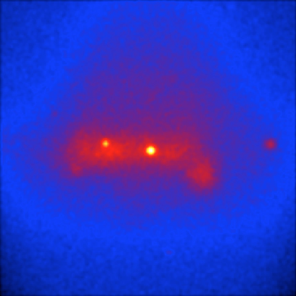
Sky map of the events recorded around the Galactic Centre during the Galactic Plane Survey
The sky map shows a wide-spread distribution of events with several sources
superimposed.
Many of the events originate from an irreducable background that hampers the
recognition of the gamma-ray sources.
To describe the irreducable background in the CTA data, templates of the
background event distribution are included in the
instrument response functions.
These templates can be used by ctskymap to subtract the irreducable
background contribution from the sky map.
The background subtraction is enabled by running the ctskymap with
the background subtraction method set to IRF, as shown in the following
example:
$ ctskymap
Input event list or observation definition XML file [obs_selected.xml]
Coordinate system (CEL - celestial, GAL - galactic) (CEL|GAL) [GAL]
Projection method (AIT|AZP|CAR|GLS|MER|MOL|SFL|SIN|STG|TAN) [CAR]
First coordinate of image center in degrees (RA or galactic l) (0-360) [0.0]
Second coordinate of image center in degrees (DEC or galactic b) (-90-90) [0.0]
Image scale (in degrees/pixel) [0.02]
Size of the X axis in pixels [300]
Size of the Y axis in pixels [300]
Lower energy limit (TeV) [0.1]
Upper energy limit (TeV) [100.0]
Background subtraction method (NONE|IRF|RING) [NONE] IRF
Output skymap file [skymap.fits] skymap_irf.fits
The figure below shows the resulting sky map. The irreducable background has been subtracted from the sky map and the sources of gamma-ray emission are now clearly discernable.
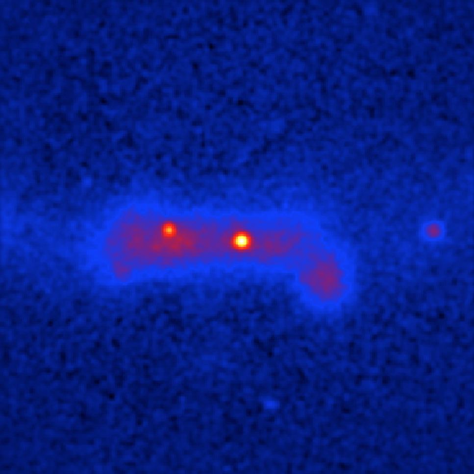
IRF background subtracted sky map of the events recorded around the Galactic Centre during the Galactic Plane Survey
In reality, however, the distribution of the irreducable background may only be
purely known, and it may be necessary to estimate the background from the data
themselves.
This can be achieved by the so called ring background method, that estimates the
background rate from a ring around a given position.
The ring background can be used by specifying RING as the background
subtraction method. ctskymap will then query for the source region and
ring radii. In addition, ctskymap provides an automatic iterative
computation of an exclusion region which are pixels with significant gamma-ray
emission that should be excluded from the ring background estimate. The tool
will query for the number of iterations (typically 3 is sufficient) and a
significance threshold for exclusion region computation.
Now type the following:
$ ctskymap
Input event list or observation definition XML file [obs_selected.xml]
Coordinate system (CEL - celestial, GAL - galactic) (CEL|GAL) [GAL]
Projection method (AIT|AZP|CAR|GLS|MER|MOL|SFL|SIN|STG|TAN) [CAR]
First coordinate of image center in degrees (RA or galactic l) (0-360) [0.0]
Second coordinate of image center in degrees (DEC or galactic b) (-90-90) [0.0]
Image scale (in degrees/pixel) [0.02]
Size of the X axis in pixels [300]
Size of the Y axis in pixels [300]
Lower energy limit (TeV) [0.1]
Upper energy limit (TeV) [100.0]
Background subtraction method (NONE|IRF|RING) [IRF] RING
Source region radius for estimating on-counts (degrees) [0.1] 0.05
Inner background ring radius (degrees) [0.6]
Outer background ring radius (degrees) [0.8]
Number of iterations for exclusion regions computation (0-100) [0] 3
Significance threshold for exclusion regions computation [5.0] 3.0
Output skymap file [skymap_irf.fits] skymap_ring.fits
The figure below shows the resulting sky map.
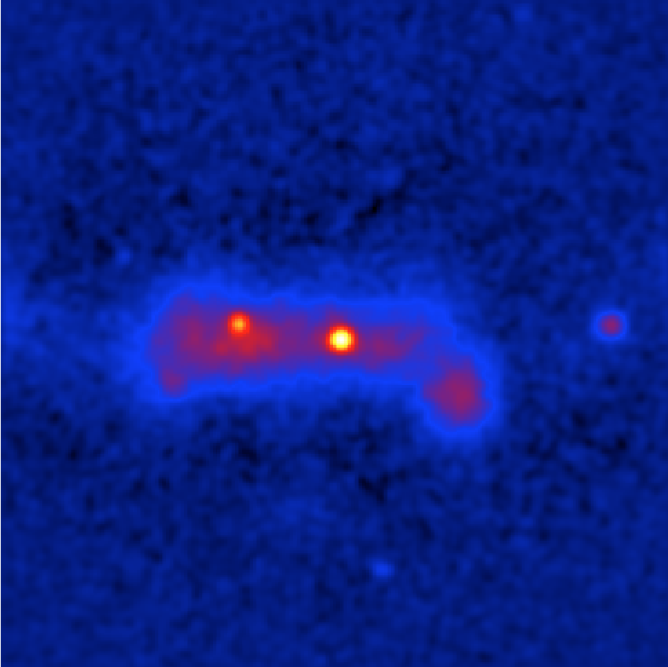
Ring background subtracted sky map of the events recorded around the Galactic Centre during the Galactic Plane Survey