Data organisation
Layout
The content of the 1dc folder should be as follows:
caldb/
caldb/data
caldb/data/cta
caldb/data/cta/1dc
caldb/data/cta/1dc/caldb.indx
caldb/data/cta/1dc/bcf
...
data/baseline/agn
data/baseline/agn/agn_baseline_510000.fits
data/baseline/agn/agn_baseline_510001.fits
...
data/
data/baseline/
data/baseline/egal
data/baseline/egal/egal_baseline_210000.fits
data/baseline/egal/egal_baseline_210001.fits
...
data/baseline/gc
data/baseline/gc/gc_baseline_310000.fits
data/baseline/gc/gc_baseline_310001.fits
...
data/baseline/gps
data/baseline/gps/gps_baseline_110000.fits
data/baseline/gps/gps_baseline_110001.fits
...
models/
models/models_agn.xml
models/models_egal.xml
models/models_gc.xml
models/models_gps.xml
...
obs/
obs/obs_agn_baseline.xml
obs/obs_egal_baseline.xml
obs/obs_gc_baseline.xml
obs/obs_gps_baseline.xml
Instrument Response Functions
The caldb folder contains the
instrument response functions
that are necessary for the analysis of the simulated CTA data.
The folder contains the 1dc response that should be used for the
first CTA Data Challenge.
Specifically, the following response functions are available:
Response name
Site
Configuration
Zenith
Duration
South_z20_50hSouth
Baseline
20 deg
50 hours
South_z40_50hSouth
Baseline
40 deg
50 hours
North_z20_50hNorth
Baseline
20 deg
50 hours
North_z40_50hNorth
Baseline
40 deg
50 hours
Event data
The data folder contains the calibrated, reconstructed and background
reduced event data that were procuded for the
first CTA Data Challenge
and that were stored into FITS files.
Event data are split into observations with a fixed
pointing direction (observations are also known as runs).
The duration of an observation is 25 minutes for the Extragalactic Survey,
30 minutes for the Galactic Plane and Centre surveys, and 15 min for the AGN
monitoring program.
The properties of the event data for all simulations are summarised in the
table below:
Parameter
GPS
GC
EGAL
AGN
Number of observations
3270
1671
1271
3840
Duration of each observation
1800 s
1800 s
1500 s
900 s
Deadtime fraction
2%
2%
2%
2%
Total exposure time of simulation
1635 h
835.5 h
529.58 h
960.00 h
Simulated event energies
30 GeV - 160 TeV
30 GeV - 160 TeV
30 GeV - 160 TeV
30 GeV - 50 TeV
Maximum off-axis angle
5 deg
5 deg
5 deg
5 deg
Start date of observations
2021-01-01
2021-01-01
2021-01-01
2021-01-01
End date of observations
2021-04-18
2021-03-29
2021-02-25
2022-07-09
Each event file contains the events for an observation and comprises an event list and a good time intervals binary table extension (see figure below).

Structure of an event file
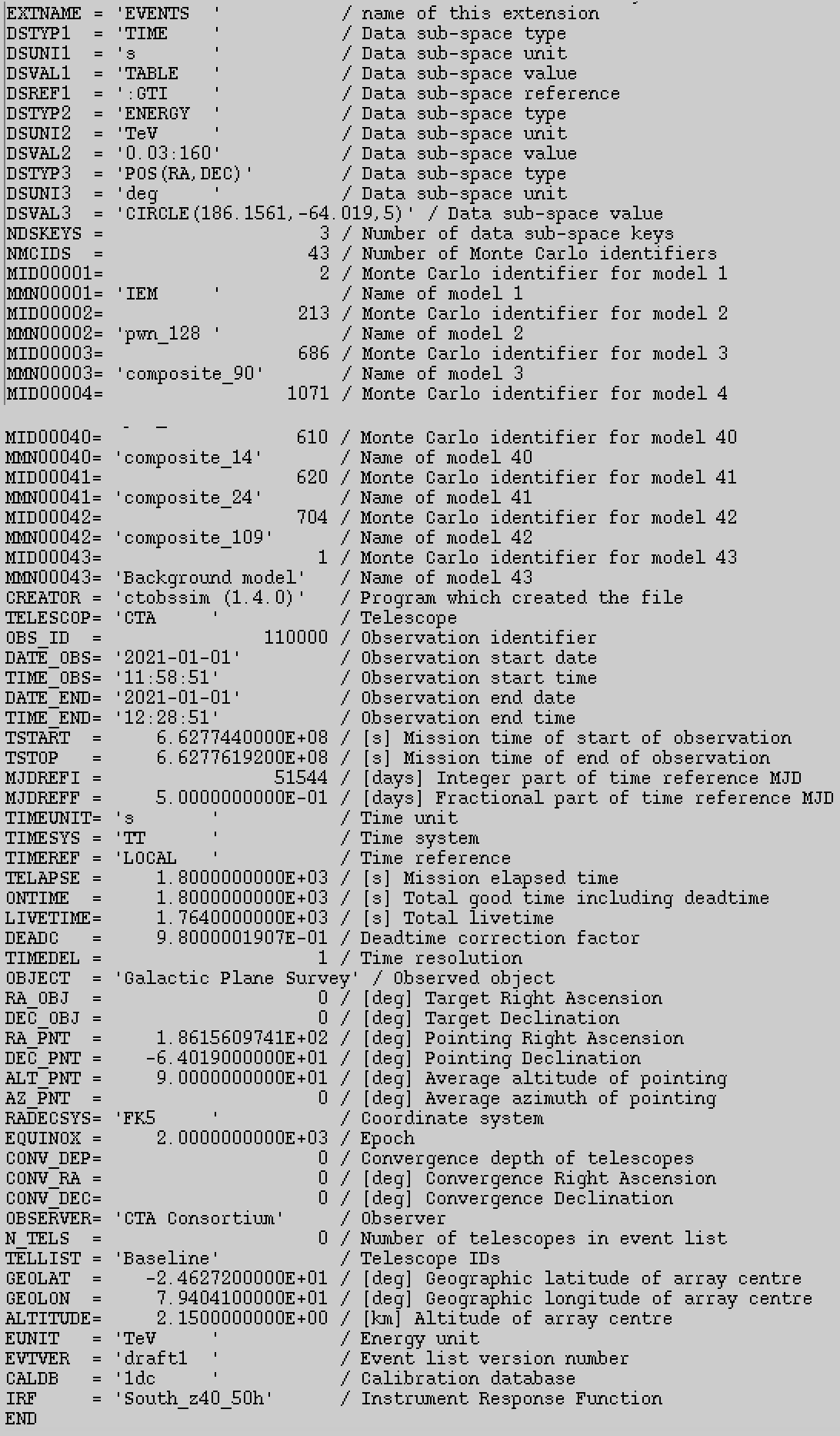
The header of the EVENTS table contains information about the
observation
such as
the start and stop date and time,
the duration and livetime of the observation, and
the pointing direction in Right Ascension and Declination.
In addition, the header contains the names and identifiers of the sources that
have been simulated (see figure below).

Header of an event list
Warning
Only the following header keywords in the EVENTS table have meaningful
values:
DSTYPx- Data sub-space typeDSUNIx- Data sub-space unitDSVALx- Data sub-space valueDSREFx- Data sub-space referenceNDSKEYS- Number of data sub-space keysNMCIDS- Number of Monte Carlo identifiersMIDxxxxx- Monte Carlo identifierMMNxxxxx- Model name for Monte Carlo identifierOBS_ID- Observation identifierDATE_OBS- start date of observation (UTC)TIME_OBS- start time of observation (UTC)DATE_END- end date of observation (UTC)TIME_END- end time of observation (UTC)TSTART- start time of observation, counted from time reference (s)TSTOP- stop time of observation, counted from time reference (s)MJDREFI- integer part of time reference MJD (days)MJDREFF- fractional part of time reference MJD (days)TIMEUNIT- time unitTIMESYS- time systemTIMEREF- time referenceTELAPSE- elapsed time (s)ONTIME- exposure time (s)LIVETIME- livetime (s)DEADC- deadtime correction factor, livetime / exposure timeTIMEDEL- time resolutionRA_PNT- Right Ascension of pointing direction (deg)DEC_PNT- Declination of pointing direction (deg)RADECSYS- Coordinate systemEQUINOX- Coordinate epoch
All remaining header keywords have arbitrary values and should not be used for the analysis.
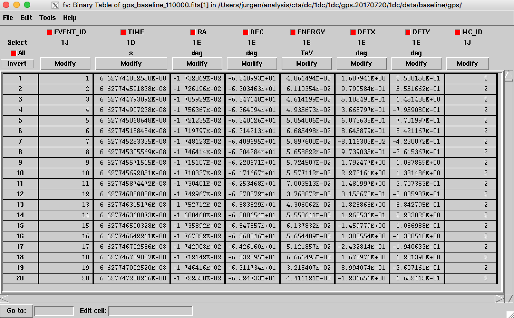
Each row of the EVENTS table corresponds to a single event.
Each event is characterised by
Column
Meaning
Unit
EVENT_IDEvent number in file
unitless
TIMETime stamp, countered from time reference
s
RAReconstructed Right Ascension
deg
DECReconstructed Declination
deg
ENERGYReconstructed energy
TeV
DETXReconstructed camera X coordinate
deg
DETYReconstructed camera Y coordinate
deg
MC_IDMonte Carlo identifier
unitless
An example of an EVENTS table is shown below.

Content of an event list
Warning
The time stamps in the TIME column are not necessarily in ascending
order.
Observation Definition Files
The files obs_agn_baseline.xml, obs_egal_baseline.xml,
obs_gc_baseline.xml, and obs_gps_baseline.xml are so called
observation definition files
containing the information (or metadata) of a list of observations.
The file is a plain ASCII files in XML format that can be inspected and
manipulated by any text editor.
Models
The models folder contains the definitions of all source and background
models that were used for simulating the data.
The files models_agn.xml, models_egal.xml, models_gc.xml and
models_gps.xml are so called
model definition files
collecting the definition of all model components used for the three surveys.
Since the same sky model was used for all surveys the four files are
identical.
The other files in the folder are ASCII and FITS files containing spectral,
temporal and spatial information that was used in the simulations.
Warning
The ASCII and FITS files should always reside in the same folder as the model definition XML files since the latter reference the former.